


About the Cover
Vol. 98 No. 2 (2022)
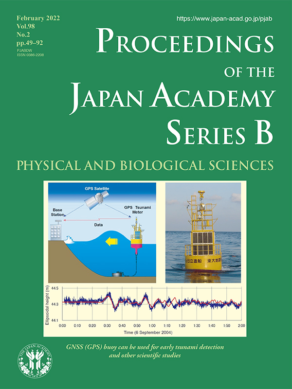
A global navigation satellite system (GNSS), which was known as the Global Positioning System (GPS), is a technology for estimating the position of a receiver placed on the earth’s surface using satellites. The precise application of the technique can provide a few centimeters’ accuracy for the positioning; therefore, it has been widely used in crustal deformation research over the globe since the late 1980s. Dr. Teruyuki Kato and colleagues first applied the technique to detect tsunami by putting the GNSS receiver on an ocean buoy and continued the developments for more than 20 years (see the review article in this issue pp. 49-71). The top-left figure of the front page shows the first concept of the GNSS (GPS) buoy, for which the position of the buoy was estimated relative to that of the base station placed on the land. This early GNSS buoy system was established near Ofunato City, Northeast Japan, and could detect tsunamis that had amplitudes of several centimeters of height for the 2001 Peru earthquake (Mw8.4) and the 2003 Tokachi-oki earthquake (Mw7.9). The second buoy established off Cape Muroto, Shikoku, southwest Japan, (top right) detected a tsunami for the 2004 Kii-Hanto Oki earthquake (Mw7.3). The plot shown below the figure is the obtained record of the tsunami and the simulated theoretical record has been added, which shows a clear consistency between them. Then, the system was implemented in the nationwide ocean wave monitoring system (called NOWPHAS in Japan) in 2008 and fifteen GNSS buoys had been established around the Japanese coasts until 2011. The records of NOWPHAS buoys were used to update tsunami alerts by the Japan Meteorological Agency, owing to the tsunami caused by the 2011 Tohoku-oki earthquake (Mw9.0). However, the system used a relative positioning and had a distance limit between the land base and buoy as less than 20 km. A new system was designed by introducing a new positioning algorithm that enables point positioning using a single receiver and satellite data transmission to place the buoy much farther from the coast. It may be placed at any place in the ocean. A new technique for continuous monitoring of ocean bottom crustal movements was also implemented in the new system. The new buoy system can be used for other fields in earth sciences, such as weather forecasting and ionospheric monitoring, using the byproducts of the GNSS positioning analyses.
Yoshio Fukao
Member of the Japan Academy